

When wildland fire crews set out to tame a blazing wildfire, they have to contend with more than just the flames. Wildfires often start in remote areas, making it difficult to move people and supplies to the front lines. Shifting terrain and weather patterns make predicting a fire’s path difficult—a sudden change in wind direction can drastically alter the course of a wildfire. But once a wildfire starts, fire crews’ biggest battle is often against time.
Data from Headwater Economics shows that over the past 20 years, 1,921 communities across the United States have experienced one or more large-scale wildfires within two miles of town. This includes highly populated cities like Los Angeles, San Diego, and Houston. As urban development continues to extend into forested areas, the number of at-risk communities will rise. And while two miles may seem like a substantial buffer between city and fire, a wildfire can quickly cover that distance on a windy day.
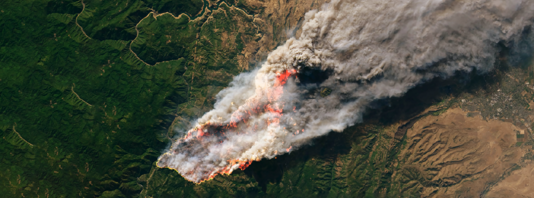
Even in our modern age, where global communication is nearly instantaneous, some wildland fires still burn undetected for hours at a time. Fatal incidents, including the Camp Fire and Dixie Fire of 2020, saw slow responses due to initial detection. It is time to modernize the way we detect and respond to fires, especially when they burn near populated areas.
With the support of policymakers, integrating better satellite detection and imagery for wildfire detection can be the future of firefighting. The implementation of this technology could give first responders a valuable head start in the fight to save at-risk communities.
Traditional wildfire detection is too slow
There are a number of ways wildfires are currently identified and reported. These include emergency hotlines (e.g., someone calls 911 when they notice a smoke plume) or watchtowers built for fire detection. When fires are caused by or impact utility lines, the utility is alerted to the power outage and sends an employee to investigate the cause.
In the case of the Dixie Fire, nearly ten hours passed before response crews reached the ignition site. By the time a full response crew was on the scene, 500 acres were already burning. Today, the Dixie Fire still holds the record for the largest wildfire in US history. It burned nearly 1 million acres—roughly the size of Rhode Island—and destroyed 1,300 structures. Faster detection and response times might have substantially reduced that damage.
Current detection strategies are almost wholly reliant on chance sightings by individuals. But people don’t have thermal eyesight. They can’t spot smoke plumes in the dark. They can’t peer over mountaintops or see through hillsides. Many won’t perceive a wildfire as a major threat until it has grown out of hand. Fortunately, we have technology at our disposal today that can do all those things and more.
Satellites and wildfires
Satellites have possessed the capability of detecting fires for years. In fact, 1980 was the first instance where a satellite, NASA’s NOAA-6, detected fires on Earth’s surface. Operators used satellite images to identify small flames coming from oil wells where companies were flaring methane gas (this process turns methane into carbon dioxide by burning it).
Current NASA satellites, however, are not ideal for wildfire detection. Specifically, NASA’s satellites are in no hurry when it comes to transmitting images. The association’s long-standing satellite sensors only relay wildfire information twice a day. Realistically, almost any alternative detection method can detect a wildfire faster than NASA. Fortunately, there are some other, more promising satellite options.
Innovators at the University of California Berkeley have pioneered a newer, more efficient method of wildfire detection known as the Fire Urgency Estimator in Geosynchronous Orbit (FUEGO for short). It has laid the groundwork for a new age of wildfire detection satellites.
FUEGO relies on its own satellite imaging capabilities combined with computer algorithms to detect fire indicators. Upon detection, it alerts fire responders on the ground, who can choose how to respond. The satellite itself would be able to capture images from an area spanning the Western United States, which conveniently is where most wildfires occur.
The best part? FUEGO has the ability to cut detection time down to two minutes.
Due to a host of obstacles, the project has yet to make it off the ground. However, FUEGO’s technology is being implemented in other private wildfire detection projects as well. Exci, an Australian wildfire detection company, is also making a name for itself.
The system combines FUEGO’s satellite tech and machines with ground cameras for quick detection. Exci boasts the ability to detect 66 percent of fires within a minute, 95 percent within five minutes, and nearly 100 percent within ten minutes, with a near-zero rate of false positives. The company plans to launch its satellite in the next few years. Once fully operational, Exci, and systems like it, will allow responders to identify fires more quickly and confidently than has ever previously been possible.
Making satellite detection a reality
The main obstacle to wildfire detection programs like FUEGO and Exci is finding their way into orbit. Launching a satellite is no small process, and it poses a difficult set of challenges.
Centralize space regulation
The first hurdle that must be overcome is obtaining legal approval. Federal regulations on space activity make obtaining permissions a tedious and expensive process. The process of governmental approval of a satellite launch follows a general pattern.
First, candidates must get a launch license from the Federal Aviation Administration (FAA). If the satellite has remote sensing capabilities, a license from the Department of Commerce is also necessary. More licenses are required from the Federal Communications Commission, Department of State, and other organizations. The chart below lists the various organizations and oversight requirements groups must meet before receiving approval:
Despite the obstacles, some commercial satellite projects do get approved. As of 2018, 119 remote sensing licenses have been granted to around 1,000 imaging satellites, owned by both private corporations as well as universities.
This challenge isn’t unique to wildfire technology. Other industries have submitted proposals to centralize all licenses for commercial spacecraft under one government organization. This would look something like making the FAA the primary resource for space entrepreneurs. Centralization would make the licensing process more viable for innovators. Up to now this solution has been largely ignored in Congress, but the wildfire issue adds an element of urgency that may change some minds. Streamlining this process could make it easier to test, innovate, and deploy these systems.
Proactively fund satellite fire detection
The second main challenge that wildfire detection satellite projects face is the high upfront cost. Without the proper financial capital, remote sensing system implementation is unlikely. For example, FUEGO’s satellite would likely cost about $300 million to build and launch. That kind of money is usually only obtained through government investment, but legal and monetary obstacles make this difficult.
Land management agencies are disincentivized from pursuing satellite projects because of barriers to cost-sharing between agencies. Retiring siloed funding policies would allow for remote sensing technology to become the norm for government wildfire efforts. Otherwise, very wealthy corporate sponsors are a must (think Elon Musk’s Starlink).
Even with agency collaboration, $300 million can seem like a heavy price tag. But to put that into perspective, compare it with the US government’s annual spending on fire suppression. In the past 5 years, suppression spending totaled $14.3 billion — an average of nearly $3 billion per year.
That $300 million feels even smaller when compared to the damages that early detection could potentially prevent. A recent study in Nature Sustainability found that the 2018 wildfire season caused more than $148 billion of damage just in the state of California. The $300 million cost is a tiny fraction of the potential benefits a wildfire detection satellite could provide.
Spreading funding out across multiple government agencies could help incentivize such investments. Even with significant policy barriers, the US government has backed many commercial space companies since the industry’s emergence in the 2000s. These products have been used for national defense, disaster mapping and response, and the general benefit of society.
In fact, the government recently invested in Planet Labs, a remote sensing company. The company’s mission is to provide satellite imagery to solve issues ranging from traffic to flood monitoring. Placing a similar value on wildfire prevention should be a priority.
Entrepreneurs, policymakers, and innovators alike should invest in a future where fires can be detected within minutes of being started and put out within hours. Having the power to quickly detect wildfires that put communities at risk will only get more important as wildfire seasons continue to lengthen and communities continue to develop in wildfire-prone regions.
With a little collaboration, satellites can become an effective tool in the belt of fire responders.